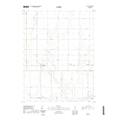
2021 Map of La Place
USGS Topo · Published 2021About this map
LaPlace and Lake City anchor this Illinois agricultural landscape, where the geometry of the Public Land Survey System is etched into the modern road network. The map reveals a transition between Macon, Piatt, and Moultrie counties, defined by the headwaters and drainage of the W Okaw River. Local history is preserved in the placement of the La Place Cem and Turner Cem, alongside small rural junctions like Lintner and Burrowsville. The heavy reliance on managed water systems is evident through the naming of the Hammond Mutual Ditch, Ditch Number 3, and Ditch Number 4, which dictate the drainage patterns across these prairie lands. For genealogists and local researchers, the map provides a precise look at the township grid, showing how the rural community is structured around arterial routes like N State Rte 32 and Co Hwy 12.
Find a feature on this map
35 named features on this map. Tap any name to fly to it.
Don’t see what you’re looking for? This feature index may not catch every label — zoom into the map to look around manually.
Map Details
Editions of this 2021 La Place Map
This is the sole edition of this map. No revisions or reprints were ever made.
Other maps of this area

1929 · Decatur
USGS Topo · 1:62,500

1933 · Decatur
USGS Topo · 1:62,500

1935 · Sullivan
USGS Topo · 1:48,000

1940 · Sullivan
USGS Topo · 1:62,500

1949 · Dalton City
USGS Topo · 1:62,500

1955 · Bement
USGS Topo · 1:62,500

1958 · Decatur
USGS Topo · 1:250,000

1961 · Decatur
USGS Topo · 1:250,000

1967 · Long Creek
USGS Topo · 1:24,000
1967 · Argenta
USGS Topo · 1:24,000