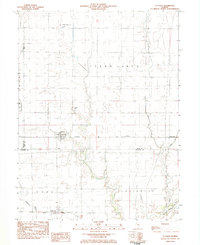
1983 Map of La Place
USGS Topo · Published 1983About this map
LaPlace serves as the central hub of this agricultural landscape in the early 1980s, situated at the intersection of the Baltimore and Ohio railroad and several local routes. The terrain is defined by its drainage patterns, with the Okaw river system and engineered waterways like Hammond Mutual Ditch and the North No. 3 Ditch carving through the flatlands of Cerro Gordo and Dora townships. Small settlements and former rail stops like Lintner and Burrowsville appear as modest clusters against the vast grid of section lines.
Find a feature on this map
26 named features on this map. Tap any name to fly to it.
Don’t see what you’re looking for? This feature index may not catch every label — zoom into the map to look around manually.
Map Details
Editions of this 1983 La Place Map
This is the sole edition of this map. No revisions or reprints were ever made.
Other maps of this area

1929 · Decatur
USGS Topo · 1:62,500

1933 · Decatur
USGS Topo · 1:62,500

1935 · Sullivan
USGS Topo · 1:48,000

1940 · Sullivan
USGS Topo · 1:62,500

1949 · Dalton City
USGS Topo · 1:62,500

1955 · Bement
USGS Topo · 1:62,500

1958 · Decatur
USGS Topo · 1:250,000

1961 · Decatur
USGS Topo · 1:250,000

1967 · Long Creek
USGS Topo · 1:24,000
1967 · Argenta
USGS Topo · 1:24,000