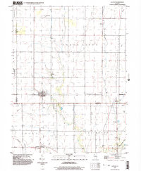
1999 Map of La Place
USGS Topo · Published 2003About this map
LaPlace and Lake City anchor this Illinois landscape at the close of the twentieth century, marking a region defined by agricultural grid patterns and extensive water management. The terrain is crisscrossed by essential drainage systems like No 3 Ditch and the Hammond Mutual Ditch, which support the productive farmlands between the Stringtown Branch and the Okaw river. Small rail-side or crossroads settlements like Lintner and Burrowsville appear as modest clusters of activity in this rural expanse.
Find a feature on this map
27 named features on this map. Tap any name to fly to it.
Don’t see what you’re looking for? This feature index may not catch every label — zoom into the map to look around manually.
Map Details
Editions of this 1999 La Place Map
This is the sole edition of this map. No revisions or reprints were ever made.
Other maps of this area

1929 · Decatur
USGS Topo · 1:62,500

1933 · Decatur
USGS Topo · 1:62,500

1935 · Sullivan
USGS Topo · 1:48,000

1940 · Sullivan
USGS Topo · 1:62,500

1949 · Dalton City
USGS Topo · 1:62,500

1955 · Bement
USGS Topo · 1:62,500

1958 · Decatur
USGS Topo · 1:250,000

1961 · Decatur
USGS Topo · 1:250,000

1967 · Long Creek
USGS Topo · 1:24,000
1967 · Argenta
USGS Topo · 1:24,000