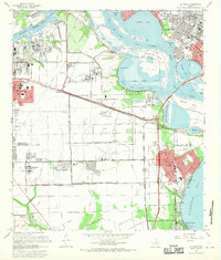
1967 Map of La Porte
USGS Topo · Published 1970About this map
The San Jacinto State Park stands as a prominent historical landmark at the confluence of the Buffalo Bayou and the San Jacinto River during this 1960s era. The landscape is defined by the industrial and maritime infrastructure of the Houston Ship Channel, which carves through the bays and marshes. Residential growth is evident in Deer Park, Lomax, and La Porte, where grid-patterned neighborhoods meet the edge of the Galveston Bay shoreline. To the south, the Clear Lake Oil Field indicates the region's energy-based economy, while schools like San Jacinto College and Lee College point toward mid-century civic development. Educational and spiritual foundations are anchored by Spencer Park Chapel and local cemeteries including Grandview Memorial Park and Betheny Cem, reflecting the deep community roots established as the Houston metro area expanded eastward toward the coast.
Find a feature on this map
59 named features on this map. Tap any name to fly to it.
Don’t see what you’re looking for? This feature index may not catch every label — zoom into the map to look around manually.
Map Details
Editions of this 1967 La Porte Map
This is the sole edition of this map. No revisions or reprints were ever made.
Other maps of this area

1915 · Deepwater
USGS Topo · 1:24,000

1916 · Genoa
USGS Topo · 1:24,000

1916 · Burnett Bay
USGS Topo · 1:24,000

1916 · Morgan Point
USGS Topo · 1:24,000

1916 · Seabrook
USGS Topo · 1:24,000

1916 · Fauna
USGS Topo · 1:24,000

1916 · Cedar Bayou
USGS Topo · 1:24,000

1916 · La Porte
USGS Topo · 1:24,000

1919 · Morgan Point
USGS Topo · 1:31,680

1919 · Deepwater
USGS Topo · 1:31,680