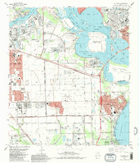
1982 Map of La Porte
USGS Topo · Published 1983About this map
Industrial expansion and residential growth define the landscape of eastern Harris County in the early 1980s. The Houston Ship Channel and Buffalo Bayou serve as the primary arteries for commerce, leading past the massive infrastructure of Jacintoport and the petrochemical hubs of Baytown and Deer Park. This survey illustrates the intricate balance between heavy industry and civic life, showing the established neighborhoods of La Porte alongside recreational spaces like San Jacinto State Park and Sylvan Beach Park.
Find a feature on this map
56 named features on this map. Tap any name to fly to it.
Don’t see what you’re looking for? This feature index may not catch every label — zoom into the map to look around manually.
Map Details
Editions of this 1982 La Porte Map
This is the sole edition of this map. No revisions or reprints were ever made.
Other maps of this area

1915 · Deepwater
USGS Topo · 1:24,000

1916 · Genoa
USGS Topo · 1:24,000

1916 · Burnett Bay
USGS Topo · 1:24,000

1916 · Morgan Point
USGS Topo · 1:24,000

1916 · Seabrook
USGS Topo · 1:24,000

1916 · Fauna
USGS Topo · 1:24,000

1916 · Cedar Bayou
USGS Topo · 1:24,000

1916 · La Porte
USGS Topo · 1:24,000

1919 · Morgan Point
USGS Topo · 1:31,680

1919 · Deepwater
USGS Topo · 1:31,680