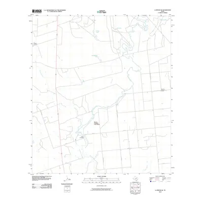
2010 Map of La Pryor SE
USGS Topo · Published 2010About this map
Nueces Campsite Lots Colonia serves as a primary residential point in this South Texas landscape, situated near the winding course of the Nueces River. The region is defined by a ranching and resource-management economy, evidenced by numerous livestock water tanks such as Cambalache Tank, Franklin Tank, and Gulf Tank. Water control is central to the area's geography, with structures like the T C Stricklin Lake Dam and the Upper Lake Dam regulating local flow. A network of rural farm-to-market roads and named arteries, including Ritchie Rd and Marburger Rd, connects the scattered homesteads and landings. The presence of the H and F Properties Airport highlights the importance of private aviation for navigating this expansive terrain, while drainage features like Cambalache Creek and Alligator Slough illustrate the natural hydrology of the Brush Country.
Find a feature on this map
22 named features on this map. Tap any name to fly to it.
Don’t see what you’re looking for? This feature index may not catch every label — zoom into the map to look around manually.
Map Details
Editions of this 2010 La Pryor SE Map
This is the sole edition of this map. No revisions or reprints were ever made.
Other maps of this area

1939 · Carrizo Springs
USGS Topo · 1:62,500

1939 · Big Wells
USGS Topo · 1:62,500

1939 · La Pryor
USGS Topo · 1:62,500

1953 · Crystal City
USGS Topo · 1:250,000

1955 · Crystal City
USGS Topo · 1:250,000

1957 · Batesville
USGS Topo · 1:62,500

1961 · Crystal City
USGS Topo · 1:250,000

1968 · Crystal City
USGS Topo · 1:250,000
1972 · Beef Hollow Creek
USGS Topo · 1:24,000
1972 · La Pryor NW
USGS Topo · 1:24,000