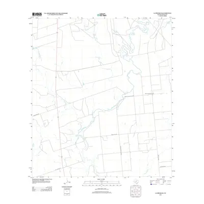
2013 Map of La Pryor SE
USGS Topo · Published 2013About this map
The Nueces River winds through this rural landscape in Zavala County, serving as the primary geographic corridor for the ranching and agricultural operations of the region. This 2013 survey reveals an intricate network of water management features, including several named stock ponds such as Cambalache Tank, Carper Tank, and Gulf Tank which dot the dry plains. Transportation across the territory is defined by local access routes like Zacate Ranch Rd and Farm-to-Market Road 3292, which connect the scattered homesteads and landings to larger regional hubs. The presence of the H & F Properties Airport underscores the role of private aviation in managing these large South Texas landholdings. Further south, Alligator Slough and the winding Sand Cr feed into the river system, illustrating the hydrology of this brush country terrain before it reaches the coastal plains.
Find a feature on this map
16 named features on this map. Tap any name to fly to it.
Don’t see what you’re looking for? This feature index may not catch every label — zoom into the map to look around manually.
Map Details
Editions of this 2013 La Pryor SE Map
This is the sole edition of this map. No revisions or reprints were ever made.
Other maps of this area

1939 · Carrizo Springs
USGS Topo · 1:62,500

1939 · Big Wells
USGS Topo · 1:62,500

1939 · La Pryor
USGS Topo · 1:62,500

1953 · Crystal City
USGS Topo · 1:250,000

1955 · Crystal City
USGS Topo · 1:250,000

1957 · Batesville
USGS Topo · 1:62,500

1961 · Crystal City
USGS Topo · 1:250,000

1968 · Crystal City
USGS Topo · 1:250,000
1972 · Beef Hollow Creek
USGS Topo · 1:24,000
1972 · La Pryor NW
USGS Topo · 1:24,000