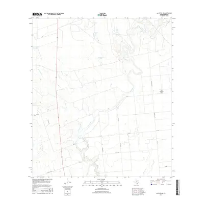
2016 Map of La Pryor SE
USGS Topo · Published 2016About this map
The Nueces River winds through this South Texas landscape in Zavala County, creating a riparian corridor defined by sharp meanders and seasonal water features. The map illustrates a ranching and industrial economy, where specialized water management is evident through numerous named reservoirs and stock ponds such as Carper Tank, Cambalache Tank, and Franklin Tank. Larger bodies of water like Upper Lake and T C Stricklin Lake provide more permanent landmarks amidst the scrubland. A network of rural farm-to-market roads and named ranch routes, including Zacate Ranch Rd and Malagena Rd, connect the scattered holdings. The presence of the H & F Properties Airport and Northern Gas Rd indicates the intersection of private aviation and regional energy infrastructure within this sparsely settled territory.
Find a feature on this map
24 named features on this map. Tap any name to fly to it.
Don’t see what you’re looking for? This feature index may not catch every label — zoom into the map to look around manually.
Map Details
Editions of this 2016 La Pryor SE Map
This is the sole edition of this map. No revisions or reprints were ever made.
Other maps of this area

1939 · Carrizo Springs
USGS Topo · 1:62,500

1939 · Big Wells
USGS Topo · 1:62,500

1939 · La Pryor
USGS Topo · 1:62,500

1953 · Crystal City
USGS Topo · 1:250,000

1955 · Crystal City
USGS Topo · 1:250,000

1957 · Batesville
USGS Topo · 1:62,500

1961 · Crystal City
USGS Topo · 1:250,000

1968 · Crystal City
USGS Topo · 1:250,000
1972 · Beef Hollow Creek
USGS Topo · 1:24,000
1972 · La Pryor NW
USGS Topo · 1:24,000