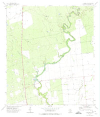
1972 Map of La Pryor SE
USGS Topo · Published 1974About this map
The Nueces River meanders through this portion of Zavala County, its path marked by significant water management and ranching infrastructure including the Upper Dam. To the west, the Missouri Pacific railroad runs parallel to Highway 83, passing through the small settlement of Zacate in the northern section of the map. This landscape is defined by its transition from riparian corridors along Sand Creek and Cambalache Creek to the industrial utility of the southern fields. Numerous Oil Wells and a Gas Well indicate the energy extraction occurring in the early 1970s, while a network of named stock tanks such as Gulf Tank, Franklin Tank, and Carper Tank reflect the area's grazing history. A remote Landing Strip and multiple pipelines further illustrate the mix of agricultural and industrial development in this South Texas region.
Find a feature on this map
19 named features on this map. Tap any name to fly to it.
Don’t see what you’re looking for? This feature index may not catch every label — zoom into the map to look around manually.
Map Details
Editions of this 1972 La Pryor SE Map
This is the sole edition of this map. No revisions or reprints were ever made.
Other maps of this area

1939 · Carrizo Springs
USGS Topo · 1:62,500

1939 · Big Wells
USGS Topo · 1:62,500

1939 · La Pryor
USGS Topo · 1:62,500

1953 · Crystal City
USGS Topo · 1:250,000

1955 · Crystal City
USGS Topo · 1:250,000

1957 · Batesville
USGS Topo · 1:62,500

1961 · Crystal City
USGS Topo · 1:250,000

1968 · Crystal City
USGS Topo · 1:250,000
1972 · Beef Hollow Creek
USGS Topo · 1:24,000
1972 · La Pryor NW
USGS Topo · 1:24,000