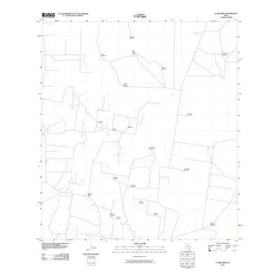
2010 Map of La Reforma
USGS Topo · Published 2010About this map
The community of Puerto Rico sits at the junction of FM 1017 and FM 881, anchoring a South Texas landscape defined by ranching infrastructure and local heritage. This 2010 survey illustrates a grid-like network of rural tracks and property boundaries, where the most prominent landmarks are a series of family and place-named windmills. These features, such as Hargrove Windmill, Alaniz Windmill, and El Torero Windmill, suggest a reliance on groundwater and the vital role of these stations in maintaining the surrounding territory.
Find a feature on this map
22 named features on this map. Tap any name to fly to it.
Don’t see what you’re looking for? This feature index may not catch every label — zoom into the map to look around manually.
Map Details
Editions of this 2010 La Reforma Map
This is the sole edition of this map. No revisions or reprints were ever made.
Other maps of this area

1939 · Linn
USGS Topo · 1:62,500

1939 · La Reforma
USGS Topo · 1:62,500

1939 · Encantada
USGS Topo · 1:62,500

1949 · Mc Allen
USGS Topo · 1:250,000

1954 · McAllen
USGS Topo · 1:250,000

1957 · Mc Allen
USGS Topo · 1:250,000

1962 · McAllen
USGS Topo · 1:250,000

1963 · Linn NW
USGS Topo · 1:24,000
1963 · Linn Siding
USGS Topo · 1:24,000
1963 · Hartland
USGS Topo · 1:24,000