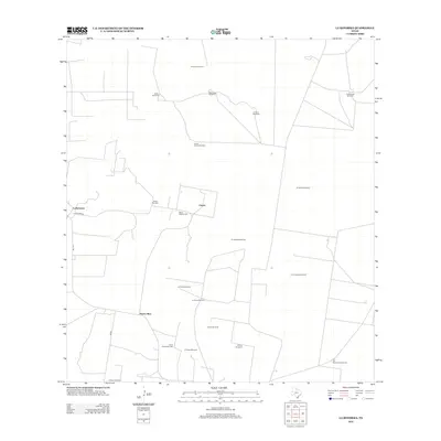
2012 Map of La Reforma
USGS Topo · Published 2012About this map
The arid landscape of Hidalgo County is defined by a sparse network of ranching outposts and vital water sources in this 2012 survey. Concentrated near La Reforma and the crossroads at Puerto Rico, the region's human geography is tied to the long-standing cattle-raising traditions of South Texas. The map reveals a reliance on groundwater, documented through a series of family-named water stations such as Bella Vista Windmill, Noche Buena Windmill, and El Chapote Windmill.
Find a feature on this map
25 named features on this map. Tap any name to fly to it.
Don’t see what you’re looking for? This feature index may not catch every label — zoom into the map to look around manually.
Map Details
Editions of this 2012 La Reforma Map
This is the sole edition of this map. No revisions or reprints were ever made.
Other maps of this area

1939 · Linn
USGS Topo · 1:62,500

1939 · La Reforma
USGS Topo · 1:62,500

1939 · Encantada
USGS Topo · 1:62,500

1949 · Mc Allen
USGS Topo · 1:250,000

1954 · McAllen
USGS Topo · 1:250,000

1957 · Mc Allen
USGS Topo · 1:250,000

1962 · McAllen
USGS Topo · 1:250,000

1963 · Linn NW
USGS Topo · 1:24,000
1963 · Linn Siding
USGS Topo · 1:24,000
1963 · Hartland
USGS Topo · 1:24,000