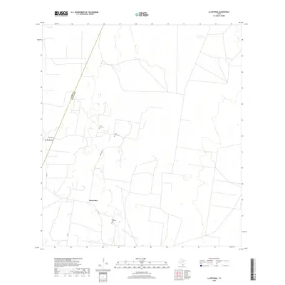
2019 Map of La Reforma
USGS Topo · Published 2019About this map
Puerto Rico and La Reforma anchor this South Texas landscape where the coastal plains meet the ranching country of the Rio Grande Valley. The geography is defined by a sparse network of ranch roads and state-maintained routes, including Fm 1017 and Fm 681, which connect isolated settlements and family holdings. For those studying local lineages and burial patterns, several small community landmarks are present, such as Santa Rita Cem, Santa Monica Cem, and Santa Guadalupe Cem. The area is bisected by the county boundary between Starr and Hidalgo Counties, a detail that often complicates land title and genealogical research. The map illustrates a contemporary view of this agricultural region, where development remains concentrated along specific corridors like Puerto Rico Rd and La Reforma Rd.
Find a feature on this map
10 named features on this map. Tap any name to fly to it.
Don’t see what you’re looking for? This feature index may not catch every label — zoom into the map to look around manually.
Map Details
Editions of this 2019 La Reforma Map
This is the sole edition of this map. No revisions or reprints were ever made.
Other maps of this area

1939 · Linn
USGS Topo · 1:62,500

1939 · La Reforma
USGS Topo · 1:62,500

1939 · Encantada
USGS Topo · 1:62,500

1949 · Mc Allen
USGS Topo · 1:250,000

1954 · McAllen
USGS Topo · 1:250,000

1957 · Mc Allen
USGS Topo · 1:250,000

1962 · McAllen
USGS Topo · 1:250,000

1963 · Linn NW
USGS Topo · 1:24,000
1963 · Linn Siding
USGS Topo · 1:24,000
1963 · Hartland
USGS Topo · 1:24,000