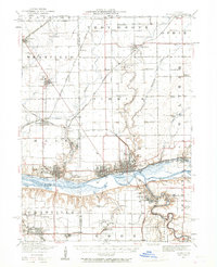
1947 Map of La Salle
USGS Topo · Published 1967About this map
The Illinois River corridor serves as the industrial and logistical heart of this region, where the twin cities of La Salle and Peru sit at a critical intersection of waterway and rail traffic. By the late 1940s, the landscape reflects a mature industrial economy, with the Chicago Rock Island and Pacific RR and the Illinois Central RR facilitating heavy transport alongside the river and its southern banks near Oglesby. The topography is sharply defined by the Vermilion River and Little Vermilion River, which carve deep valleys into the prairie before meeting the main river channel near Split Rock. South of the river, the presence of Deer Park and Matthiessen Park highlights the early preservation of the area's unique geological features. Further inland, the map captures a rural network of small-town centers like Troy Grove and Arlington, interspersed with legacy institutions such as St Bedes College and numerous named rural schoolhouses like Waltham School and Whipple School.
Find a feature on this map
74 named features on this map. Tap any name to fly to it.
Don’t see what you’re looking for? This feature index may not catch every label — zoom into the map to look around manually.
Map Details
Editions of this 1947 La Salle Map
2 editions found

Other maps of this area

1892 · Ottawa
USGS Topo · 1:62,500

1893 · Lacon
USGS Topo · 1:62,500

1893 · Hennepin
USGS Topo · 1:62,500

1893 · Lasalle
USGS Topo · 1:62,500

1909 · Hennepin
USGS Topo · 1:62,500

1911 · La Salle
USGS Topo · 1:62,500

1911 · Hennepin
USGS Topo · 1:62,500

1913 · La Salle
USGS Topo · 1:62,500

1915 · Ottawa
USGS Topo · 1:62,500

1925 · Streator
USGS Topo · 1:62,500