
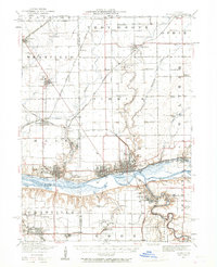
1947 Map of La Salle
USGS Topo · Published 1958About this map
The Illinois River serves as the industrial and geographic anchor of this mid-century landscape, flanked by the prominent urban centers of La Salle, Peru, and Spring Valley. A dense network of railroads, including the Chicago Rock Island and Pacific RR and the Chicago Burlington and Quincy RR, crisscrosses the river valley, illustrating the region's importance as a transportation hub for coal and agriculture. This 1940s revision documents the post-war state of these river towns, where St Bedes College and Webster Park overlook the valley floor.
Find a feature on this map
80 named features on this map. Tap any name to fly to it.
Don’t see what you’re looking for? This feature index may not catch every label — zoom into the map to look around manually.
Map Details
Editions of this 1947 La Salle Map
2 editions found
Other maps of this area

1892 · Ottawa
USGS Topo · 1:62,500

1893 · Lacon
USGS Topo · 1:62,500

1893 · Hennepin
USGS Topo · 1:62,500

1893 · Lasalle
USGS Topo · 1:62,500

1909 · Hennepin
USGS Topo · 1:62,500

1911 · La Salle
USGS Topo · 1:62,500

1911 · Hennepin
USGS Topo · 1:62,500

1913 · La Salle
USGS Topo · 1:62,500

1915 · Ottawa
USGS Topo · 1:62,500

1925 · Streator
USGS Topo · 1:62,500