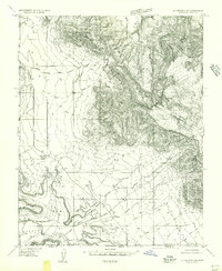
1954 Map of La Verkin 4 SE
USGS Topo · Published 1956About this map
Canaan Mountain dominates this portion of the borderlands where the Utah-Arizona state line meets the boundary between Washington and Mohave counties. The 1954 survey captures a landscape of extreme verticality, defined by the sheer Escarpment of the Great Basin. Small-scale ranching and local travel routes are evidenced by the Canaan Ranch and the crossroads at Big Plain Junction.
Find a feature on this map
11 named features on this map. Tap any name to fly to it.
Don’t see what you’re looking for? This feature index may not catch every label — zoom into the map to look around manually.
Map Details
Editions of this 1954 La Verkin 4 SE Map
2 editions found
Other maps of this area

1885 · St. George
USGS Topo · 1:250,000

1886 · Kanab
USGS Topo · 1:250,000

1886 · Mt. Trumbull
USGS Topo · 1:250,000

1886 · Kaibab
USGS Topo · 1:250,000

1891 · St. George
USGS Topo · 1:250,000

1892 · Mt. Trumbull
USGS Topo · 1:250,000

1953 · Cedar City
USGS Topo · 1:250,000

1953 · Grand Canyon
USGS Topo · 1:250,000

1954 · La Verkin 4 SE
USGS Topo · 1:24,000

1954 · La Verkin 4 NW
USGS Topo · 1:24,000