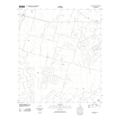
2010 Map of La Vernia SW
USGS Topo · Published 2010About this map
Lone Oak and La Vernia anchor the northern reaches of this landscape, where suburban residential growth meets the enduring rural character of Wilson and Bexar counties. The map captures a transitional moment for local infrastructure, documenting numerous named private drives like Bluebonnet Ln and Morning Glory Ln that signal the subdivision of older ranch lands. Aviation and industry are present through the McCreless Farm Airport and the Cooksey Oil Field, reflecting the multi-use nature of the Texas countryside.
Find a feature on this map
72 named features on this map. Tap any name to fly to it.
Don’t see what you’re looking for? This feature index may not catch every label — zoom into the map to look around manually.
Map Details
Editions of this 2010 La Vernia SW Map
This is the sole edition of this map. No revisions or reprints were ever made.
Other maps of this area

1936 · Floresville
USGS Topo · 1:62,500

1953 · Elmendorf
USGS Topo · 1:24,000

1953 · Martinez
USGS Topo · 1:24,000

1954 · San Antonio
USGS Topo · 1:250,000

1957 · San Antonio
USGS Topo · 1:250,000

1957 · New Berlin
USGS Topo · 1:24,000

1958 · La Vernia SW
USGS Topo · 1:24,000

1958 · Saspamco
USGS Topo · 1:24,000
1958 · Saint Hedwig
USGS Topo · 1:24,000
1961 · Marcelinas Hills
USGS Topo · 1:24,000