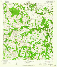
1958 Map of Saint Hedwig
USGS Topo · Published 1961About this map
Saint Hedwig anchors this East Texas landscape at a time when rural life was being intersected by modern military and industrial infrastructure. The map shows the Southern Pacific rail line cutting through the south, serving the station at Adkins and Adkins Siding, while a significant portion of the north is occupied by the Zuehl Air Force Auxiliary Field. The terrain is deeply carved by the famously named Woman Hollering Creek and Cibolo Creek, which define the county lines between Bexar, Guadalupe, and Wilson. This era of transition is evident in the presence of scattered country institutions like Annunciation Sch and Redeemer Ch, alongside the industrial footprint of a major Pipeline and new highway construction marked as Under Construction. Local history is preserved in the location of family-named schools such as Clemens Sch and Goebel Sch that served these farming communities.
Find a feature on this map
28 named features on this map. Tap any name to fly to it.
Don’t see what you’re looking for? This feature index may not catch every label — zoom into the map to look around manually.
Map Details
Editions of this 1958 Saint Hedwig Map
2 editions found
Other maps of this area

1924 · New Braunfels No 4
USGS Topo · 1:48,000

1927 · New Braunfels
USGS Topo · 1:62,500

1953 · Schertz
USGS Topo · 1:24,000

1953 · Elmendorf
USGS Topo · 1:24,000

1953 · Martinez
USGS Topo · 1:24,000

1954 · San Antonio
USGS Topo · 1:250,000

1957 · San Antonio
USGS Topo · 1:250,000

1957 · New Berlin
USGS Topo · 1:24,000

1958 · Marion
USGS Topo · 1:24,000

1958 · La Vernia SW
USGS Topo · 1:24,000