1963 Map of La Veta
USGS Topo · Published 1966About this map
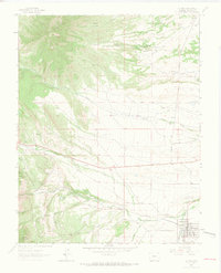
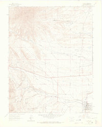
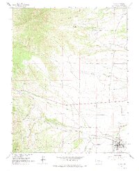
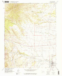
Silver Mountain dominates the northwestern skyline of this Colorado landscape, where the high desert meets the rising peaks of Huerfano County. In the valley below, the Cucharas River provides a lifeline for the town of La Veta, which serves as a central hub for the surrounding ranching and mining operations. The transport infrastructure of the early 1960s is clearly defined by the Denver and Rio Grande Western Railroad and the La Veta Landing Field. Smaller settlements and work sites like Occidental and various Gravel Pit locations suggest a history of resource extraction and seasonal labor. Water is a precious commodity here, marked by numerous named springs such as Big Canejo Springs and Dog Spring, as well as the seasonal flow through Chavez Arroyo. Local history is preserved at the Oak View Cem and across established properties like the Tres Valles Ranch.
Find a feature on this map
31 named features on this map. Tap any name to fly to it.
Don’t see what you’re looking for? This feature index may not catch every label — zoom into the map to look around manually.
Map Details
Editions of this 1963 La Veta Map
4 editions found
Other maps of this area

1889 · Huerfano Park
USGS Topo · 1:125,000

1891 · Walsenburg
USGS Topo · 1:125,000

1891 · Spanish Peaks
USGS Topo · 1:125,000

1892 · Huerfano Park
USGS Topo · 1:125,000

1893 · Spanish Peaks
USGS Topo · 1:125,000

1894 · Walsenburg
USGS Topo · 1:125,000

1895 · Spanish Peaks
USGS Topo · 1:125,000

1897 · Walsenburg
USGS Topo · 1:125,000

1897 · Spanish Peaks
USGS Topo · 1:125,000

1900 · Spanish Peaks
USGS Topo · 1:125,000