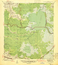
1941 Map of Lac Des Allemands
USGS Topo · Published 1941About this map
Lac Des Allemands dominates the center of this landscape, its expansive waters fed by a complex network of bayous and canals that define life in Lafourche Parish. In the early 1940s, the region’s agricultural identity is visible through the presence of several significant estates, including the Golden Star Plantation, Melodia Plantation, and Webster Plantation. These settlements follow the higher ground near Vacherie and Lower Vacherie, while the deeper interior is consumed by the expansive Rathborne Swamp.
Find a feature on this map
63 named features on this map. Tap any name to fly to it.
Don’t see what you’re looking for? This feature index may not catch every label — zoom into the map to look around manually.
Map Details
Editions of this 1941 Lac Des Allemands Map
This is the sole edition of this map. No revisions or reprints were ever made.
Other maps of this area

1891 · Hahnville
USGS Topo · 1:62,500

1892 · Lac Des Allemands
USGS Topo · 1:62,500

1892 · Mount Airy
USGS Topo · 1:62,500

1892 · Gibson
USGS Topo · 1:62,500

1892 · Bonnet Carre
USGS Topo · 1:62,500

1892 · Cut-Off
USGS Topo · 1:62,500

1892 · Houma
USGS Topo · 1:62,500

1892 · Donaldsonville
USGS Topo · 1:62,500

1892 · Thibodaux
USGS Topo · 1:62,500

1897 · Gibson
USGS Topo · 1:62,500