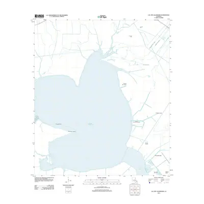
2012 Map of Lac des Allemands
USGS Topo · Published 2012About this map
Lac des Allemands dominates this coastal Louisiana landscape, where the intersection of natural bayous and industrial infrastructure reveals the region's 21st-century character. The map illustrates a complex hydraulic network where natural waterways like Bayou Chevreuil and Bayou Boeuf meet a precise grid of man-made channels including the Saint Charles Canal and Little Pecan Tree Canal. This systematic drainage and navigation system supports the area's extensive energy industry, clearly marked by the Lucy Gas Field, Lake Lucy Gas Field, and Lacs Des Allemands Gas Field. Shoreline features such as Pointe aux Herbes and Fausse Pointe define the lake's western edge, while Knights Bay Island sits near the northern inlets. This survey provides a precise record of the Louisiana wetlands during a period of active resource extraction and water management.
Find a feature on this map
26 named features on this map. Tap any name to fly to it.
Don’t see what you’re looking for? This feature index may not catch every label — zoom into the map to look around manually.
Map Details
Editions of this 2012 Lac des Allemands Map
This is the sole edition of this map. No revisions or reprints were ever made.
Other maps of this area

1891 · Hahnville
USGS Topo · 1:62,500

1892 · Lac Des Allemands
USGS Topo · 1:62,500

1892 · Mount Airy
USGS Topo · 1:62,500

1892 · Bonnet Carre
USGS Topo · 1:62,500

1932 · Lac Des Allemands NW
USGS Topo · 1:31,680

1932 · Lac Des Allemands SE
USGS Topo · 1:31,680

1932 · Lac Des Allemands SW
USGS Topo · 1:31,680

1932 · Hahnville NW
USGS Topo · 1:31,680

1932 · Lac Des Allemands NE
USGS Topo · 1:31,680

1932 · Hahnville SW
USGS Topo · 1:31,680