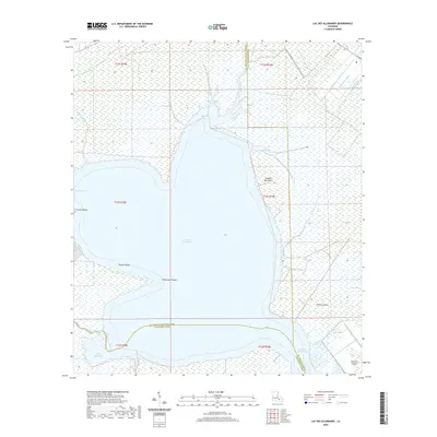
2020 Map of Lac des Allemands
USGS Topo · Published 2020About this map
Lac des Allemands dominates this landscape, a large freshwater body serving as a focal point where the borders of St. John the Baptist, St. Charles, and Lafourche Parishes converge. The surrounding wetlands are defined by an intricate network of waterways, from the natural winding paths of Bayou Chevreuil and Bayou Lasseigne to the straight, engineered lines of the Saint Charles Canal and Providence Canal. These man-made features speak to the region's history of drainage and water management for navigation and agriculture. Significant landforms like Pointe aux Herbes and Carlin Pointe reach into the lake, while small land masses such as Knights Bay Island and Bird Island provide unique markers in the marsh. This 2020 survey illustrates the delicate balance of the Louisiana coastal basin, where the water is as much a part of the geography as the low-lying points and islands.
Find a feature on this map
33 named features on this map. Tap any name to fly to it.
Don’t see what you’re looking for? This feature index may not catch every label — zoom into the map to look around manually.
Map Details
Editions of this 2020 Lac des Allemands Map
This is the sole edition of this map. No revisions or reprints were ever made.
Other maps of this area

1891 · Hahnville
USGS Topo · 1:62,500

1892 · Lac Des Allemands
USGS Topo · 1:62,500

1892 · Mount Airy
USGS Topo · 1:62,500

1892 · Bonnet Carre
USGS Topo · 1:62,500

1932 · Lac Des Allemands NW
USGS Topo · 1:31,680

1932 · Lac Des Allemands SE
USGS Topo · 1:31,680

1932 · Lac Des Allemands SW
USGS Topo · 1:31,680

1932 · Hahnville NW
USGS Topo · 1:31,680

1932 · Lac Des Allemands NE
USGS Topo · 1:31,680

1932 · Hahnville SW
USGS Topo · 1:31,680