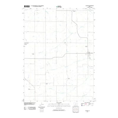
2010 Map of Lacona
USGS Topo · Published 2010About this map
Lacona and Liberty Center anchor this agricultural landscape in southeastern Warren County during the early 21st century. The map reveals a high density of rural burial grounds, including Goodes Chapel Cemetery, Shupe Cemetery, and Saint Marys Cemetery, which serve as vital markers of early settlement patterns and family genealogy for the surrounding townships. The drainage of the region is defined by a series of south-flowing waterways, most notably Wolf Creek, Cotton Creek, and Stony Creek, which wind through a grid of section roads like Roosevelt St and Virginia St. Local civic infrastructure remains centered at the Liberty Center Post Office and Lacona Post Office. This survey records the persistent rural character of the area, where small unincorporated communities continue to serve as the social hubs for a landscape of dispersed farms and wooded creek bottoms.
Find a feature on this map
33 named features on this map. Tap any name to fly to it.
Don’t see what you’re looking for? This feature index may not catch every label — zoom into the map to look around manually.
Map Details
Editions of this 2010 Lacona Map
This is the sole edition of this map. No revisions or reprints were ever made.
Other maps of this area

1910 · Milo
USGS Topo · 1:62,500

1918 · Chariton
USGS Topo · 1:62,500

1931 · Indianola
USGS Topo · 1:62,500

1950 · New Virginia
USGS Topo · 1:62,500

1952 · New Virginia
USGS Topo · 1:62,500

1954 · Des Moines
USGS Topo · 1:250,000

1956 · Des Moines
USGS Topo · 1:250,000

1957 · Des Moines
USGS Topo · 1:250,000

1965 · Milo
USGS Topo · 1:24,000
1965 · Beech
USGS Topo · 1:24,000