
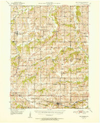
1952 Map of New Virginia
USGS Topo · Published 1952About this map
New Virginia sits at the heart of this mid-century portrait of Warren and Clarke counties, where a dense network of country schools and rural churches defines the social fabric of the Iowa countryside. The landscape is deeply carved by the South River and its numerous tributaries, including Squaw Creek and the various branches of Otter Creek. A distinct rural school system is visible through local landmarks like Quiet Dell Sch, Indian Valley Sch, and the uniquely named Eggleston Grove Sch.
Find a feature on this map
72 named features on this map. Tap any name to fly to it.
Don’t see what you’re looking for? This feature index may not catch every label — zoom into the map to look around manually.
Map Details
Editions of this 1952 New Virginia Map
2 editions found
Other maps of this area

1910 · Milo
USGS Topo · 1:62,500

1918 · Chariton
USGS Topo · 1:62,500

1931 · Indianola
USGS Topo · 1:62,500

1934 · Humeston
USGS Topo · 1:48,000

1937 · Corydon
USGS Topo · 1:62,500

1950 · New Virginia
USGS Topo · 1:62,500

1951 · Osceola
USGS Topo · 1:62,500

1951 · St. Charles
USGS Topo · 1:62,500

1954 · Centerville
USGS Topo · 1:250,000

1954 · Des Moines
USGS Topo · 1:250,000