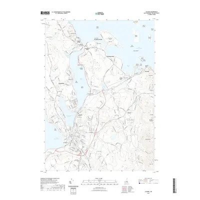
2021 Map of Laconia
USGS Topo · Published 2021About this map
Laconia and the surrounding Lake District of Belknap County are defined by a complex network of waterways, where Lake Winnipesaukee meets Paugus Bay and Opechee Bay Reservoir. This recent survey details the densely packed residential and recreational corridors connecting Lakeport to the waterfront at Weirs Beach. The landscape is a mix of established neighborhoods and seasonal retreats, with numerous islands like Governors Island and Timber Island dotting the lake's surface. Genealogists will find a concentration of burial sites including Union Cemetery, Sacred Heart Cem, and St Lamberts Cem located near the southern bend of Jewett Brook. Further east, the terrain rises toward the Belknap Mountains, home to Gunstock Mtn and Mt Rowe, illustrating the area's dual character as both a lakeside hub and a mountain destination.
Find a feature on this map
89 named features on this map. Tap any name to fly to it.
Don’t see what you’re looking for? This feature index may not catch every label — zoom into the map to look around manually.
Map Details
Editions of this 2021 Laconia Map
This is the sole edition of this map. No revisions or reprints were ever made.
Other maps of this area

1909 · Winnepesaukee
USGS Topo · 1:62,500

1919 · Gilmanton
USGS Topo · 1:62,500

1925 · Holderness
USGS Topo · 1:62,500

1927 · Penacook
USGS Topo · 1:62,500

1927 · Gilmanton
USGS Topo · 1:62,500

1927 · Holderness
USGS Topo · 1:62,500

1949 · Portland
USGS Topo · 1:250,000

1956 · Winnipesaukee
USGS Topo · 1:62,500

1956 · Penacook
USGS Topo · 1:62,500

1956 · Holderness
USGS Topo · 1:62,500