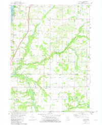
1981 Map of Lacota
USGS Topo · Published 1982About this map
The eastern shores of Lake Michigan define the western edge of this 1980s landscape, where lakefront communities like Glenn Shores and Cedar Bluff meet the agricultural interior of Casco and Geneva townships. The drainage of the Black River system, including its North, Middle, and South branches, carves through the terrain, dictating the placement of settlements and transport routes. This era shows a mix of traditional rural centers and modern utility, where local landmarks like the United Methodist Ch and Lacota Ch stand alongside aviation features such as the Sanko Landing Strip and Demler Landing Strip. Genealogists will find significant value in the documentation of numerous family or local burial sites, including the Stuller Cem, McDowell Cem, and Stephenson Cem. Small settlements like Kibbie and Lacota serve as historic anchor points along the Allegan and Van Buren county line.
Find a feature on this map
62 named features on this map. Tap any name to fly to it.
Don’t see what you’re looking for? This feature index may not catch every label — zoom into the map to look around manually.
Map Details
Editions of this 1981 Lacota Map
This is the sole edition of this map. No revisions or reprints were ever made.
Other maps of this area

1927 · Bangor
USGS Topo · 1:62,500

1927 · South Haven
USGS Topo · 1:62,500

1928 · Fennville
USGS Topo · 1:62,500

1930 · South Haven
USGS Topo · 1:62,500

1931 · Fennville
USGS Topo · 1:62,500

1931 · Bangor
USGS Topo · 1:62,500

1943 · South Haven
USGS Topo · 1:62,500

1943 · Bangor
USGS Topo · 1:62,500

1958 · Racine
USGS Topo · 1:250,000

1962 · Racine
USGS Topo · 1:250,000