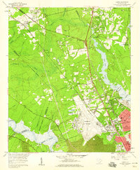
1958 Map of Ladson
USGS Topo · Published 1959About this map
Charleston Air Force Base dominates the central landscape of this late-1950s survey, illustrating the significant military footprint in the South Carolina Lowcountry. The map details the transition from rural estates and agricultural lands to organized suburban and industrial centers. Historic gardens and settlements like Magnolia Gardens and Runnymede sit along the southern banks of the Ashley River, while the northern portion is characterized by extensive wetlands such as Bluehouse Swamp and Huckhole Swamp.
Find a feature on this map
78 named features on this map. Tap any name to fly to it.
Don’t see what you’re looking for? This feature index may not catch every label — zoom into the map to look around manually.
Map Details
Editions of this 1958 Ladson Map
4 editions found
Other maps of this area

1919 · Ladson
USGS Topo · 1:21,120

1919 · Johns Island
USGS Topo · 1:21,120

1919 · Summerville
USGS Topo · 1:48,000

1919 · Cordesville
USGS Topo · 1:48,000

1919 · Melgrove
USGS Topo · 1:21,120

1919 · Charleston
USGS Topo · 1:21,120

1920 · Ravenels
USGS Topo · 1:62,500

1920 · Summerville
USGS Topo · 1:62,500

1940 · Melgrove
USGS Topo · 1:24,000

1943 · Ladson
USGS Topo · 1:24,000