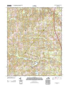
2013 Map of Ladysmith
USGS Topo · Published 2013About this map
The South River and Motto River define the local drainage of this Caroline County landscape, where modern residential development at Lake Land'Or sits alongside established rural crossroads. Traditional settlements often centered on family names and local industry, as seen at Colemans Mill and the numerous family-named junctions including Ann Wrights Corner, Nancy Wrights Corner, and Wallers Corner. In the southern portion of the quadrangle, Ladysmith Village serves as a primary hub near the Interstate corridor, contrasting with more isolated historic spots like Hams Ford on the Matta River. Genealogists and local historians can trace the transition from older agricultural patterns near Chilesburg and Blantons to the late 20th-century recreational and residential growth surrounding Lake Heritage, Lake Sussex, and Lake Dover. The geography is further marked by low-lying features such as Maple Swamp and the northern reaches of the Mat River.
Find a feature on this map
104 named features on this map. Tap any name to fly to it.
Don’t see what you’re looking for? This feature index may not catch every label — zoom into the map to look around manually.
Map Details
Editions of this 2013 Ladysmith Map
This is the sole edition of this map. No revisions or reprints were ever made.
Other maps of this area

1887 · Spottsylvania
USGS Topo · 1:125,000

1889 · Fredericksburg
USGS Topo · 1:125,000

1890 · Goochland
USGS Topo · 1:125,000

1892 · Fredericksburg
USGS Topo · 1:125,000

1892 · Spottsylvania
USGS Topo · 1:125,000

1892 · Goochland
USGS Topo · 1:125,000

1894 · Fredericksburg
USGS Topo · 1:125,000

1918 · Doswell
USGS Topo · 1:62,500

1942 · Woodford
USGS Topo · 1:31,680

1942 · Guinea
USGS Topo · 1:31,680