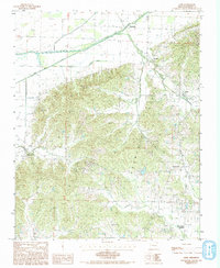
1984 Map of Lafe
USGS Topo · Published 1993About this map
Crowleys Ridge dominates the center of this landscape, rising above the lowlands of the Mississippi embayment where the Cache River and its engineered counterpart, the Cache River Ditch, drain the northwestern corner. The map captures a moment in the 1980s when the agricultural patterns of Greene County were firmly established, defined by small settlements like Lafe and Gainesville that follow the elevated terrain of the ridge. The St Louis Southwestern Railroad cuts through the northeastern sector, providing a vital transport corridor for the community of Stonewall and the surrounding farms. Local history is etched into the landscape through the numerous unnamed Cem (cemeteries) and rural crossroads such as Hooker, Beech Grove, and Oak Grove Heights, reflecting the dispersed settlement pattern typical of Northeast Arkansas. The drainage network, including Scatter Creek and Pigeon Roost Creek, illustrates the complex relationship between the rising ridge and the alluvial plains below.
Find a feature on this map
15 named features on this map. Tap any name to fly to it.
Don’t see what you’re looking for? This feature index may not catch every label — zoom into the map to look around manually.
Map Details
Editions of this 1984 Lafe Map
2 editions found
Other maps of this area

1935 · Rector
USGS Topo · 1:62,500

1935 · Knobel
USGS Topo · 1:62,500

1940 · Gainesville
USGS Topo · 1:62,500

1940 · Marmaduke
USGS Topo · 1:62,500

1941 · Knobel
USGS Topo · 1:62,500

1957 · Poplar Bluff
USGS Topo · 1:250,000

1958 · Marmaduke
USGS Topo · 1:62,500

1958 · Gainesville
USGS Topo · 1:62,500

1958 · Rector
USGS Topo · 1:62,500

1959 · Poplar Bluff
USGS Topo · 1:250,000