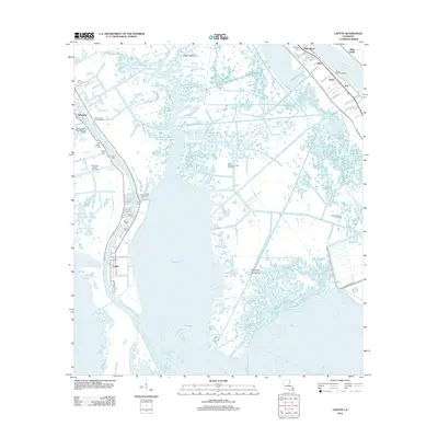
2012 Map of Lafitte
USGS Topo · Published 2012About this map
Lafitte and Barataria occupy the western bank of Bayou Cutler in this 2012 survey of the Jefferson Parish wetlands. This coastal landscape is defined by its industrial footprint, where the Barataria Oil and Gas Field and Alliance Oil and Gas Field sit amid an intricate network of waterways like The Pen and Cheniere Traverse Bayou. To the northeast, the Mississippi River forms a sharp boundary for settlements like Gloria and Star, protected by the Jesuit Bend Revetment.
Find a feature on this map
67 named features on this map. Tap any name to fly to it.
Don’t see what you’re looking for? This feature index may not catch every label — zoom into the map to look around manually.
Map Details
Editions of this 2012 Lafitte Map
This is the sole edition of this map. No revisions or reprints were ever made.
Other maps of this area

1891 · Pointe a La Hache
USGS Topo · 1:62,500

1891 · New Orleans
USGS Topo · 1:62,500

1892 · Barataria
USGS Topo · 1:62,500

1892 · St. Bernard
USGS Topo · 1:62,500

1892 · Pointe a La Hache
USGS Topo · 1:62,500

1932 · New Orleans SE
USGS Topo · 1:31,680

1932 · New Orleans SW
USGS Topo · 1:31,680

1939 · Pointe a La Hache
USGS Topo · 1:62,500
1940 · Belle Chasse
USGS Topo · 1:31,680
1940 · Bertrandville
USGS Topo · 1:31,680