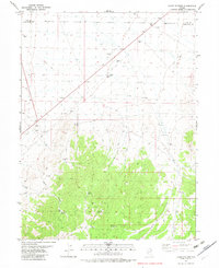
1982 Map of Lages Station
USGS Topo · Published 1982About this map
Lages Station serves as a lone outpost at the junction of Highway 93 and a network of desert routes during the early 1980s. Located along the boundary of Elko and White Pine counties, the landscape transitions from flat valley floors to the intricate drainage systems of Water Canyon and Sampson Creek. This arid environment is defined by its vital water sources, including Willow Spring, Lone Cedar Spring, and Barrel Spring, which dictate the movement of people and livestock through the high desert. Industrial activity is concentrated in numerous prospects and gravel pits, while the presence of Landing Strips suggests the area's role as a remote transit point. A web of jeep trails branches out from the main thoroughfare, providing access to the more isolated springs and canyons that characterize this Great Basin terrain.
Find a feature on this map
17 named features on this map. Tap any name to fly to it.
Don’t see what you’re looking for? This feature index may not catch every label — zoom into the map to look around manually.
Map Details
Editions of this 1982 Lages Station Map
This is the sole edition of this map. No revisions or reprints were ever made.
Other maps of this area

1955 · Elko
USGS Topo · 1:250,000

1956 · Ely
USGS Topo · 1:250,000

1958 · Elko
USGS Topo · 1:250,000

1959 · Ely
USGS Topo · 1:250,000

1962 · Elko
USGS Topo · 1:250,000

1963 · Ely
USGS Topo · 1:250,000

1965 · Elko
USGS Topo · 1:250,000

1982 · Chin Creek Spring
USGS Topo · 1:24,000
1982 · Boone Canyon
USGS Topo · 1:24,000

1982 · Cherry Spring
USGS Topo · 1:24,000