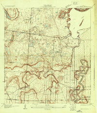
1930 Map of Laguna Atascosa
USGS Topo · Published 1930About this map
Ranching operations and tidal wetlands dominate this 1930 coastal landscape, where the flat terrain of Cameron County meets the waters of Laguna Atascosa. The map documents a transition from traditional landholdings to more formal infrastructure, evidenced by a network of straight-line thoroughfares like Line Road, East Road, and Shade Road. Large family-named holdings such as El Alazan Ranch, San Pedro Ranch, and Palo Blanco Ranch are interspersed with numerous small seasonal ponds and wetlands, illustrating the natural drainage patterns of the Rio Grande delta before modern agricultural intensification.
Find a feature on this map
26 named features on this map. Tap any name to fly to it.
Don’t see what you’re looking for? This feature index may not catch every label — zoom into the map to look around manually.
Map Details
Editions of this 1930 Laguna Atascosa Map
This is the sole edition of this map. No revisions or reprints were ever made.
Other maps of this area
1929 · Rio Hondo
USGS Topo · 1:24,000
1929 · La Coma
USGS Topo · 1:24,000
1929 · Buena Vista
USGS Topo · 1:24,000
1929 · Laguna Vista
USGS Topo · 1:24,000
1930 · Los Fresnos
USGS Topo · 1:24,000
1930 · Barreda
USGS Topo · 1:24,000
1930 · La Leona
USGS Topo · 1:24,000
1932 · Rio Hondo
USGS Topo · 1:31,680
1933 · Paso Real
USGS Topo · 1:31,680
1934 · La Coma
USGS Topo · 1:31,680
Featured Places
- Bayview, TX
- Lourdes Street Colonia, TX
- Esquina Colonia, TX
- Arroyo Gardens Number 2 Colonia, TX
- La Tina, TX