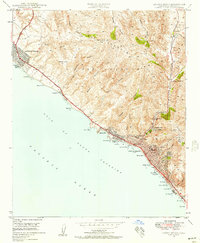
1948 Map of Laguna Beach
USGS Topo · Published 1957About this map
The coastal communities of Newport Beach and Laguna Beach are captured here in the late 1940s, a period of transition before post-war suburban development fully reshaped the Orange County shoreline. The San Joaquin Hills dominate the interior, their steep ridges cut by numerous drainages like Moro Canyon and Los Trancos Canyon that descend toward the Gulf of Santa Catalina. Along the water, a series of distinct coves and points define the landscape, including the private enclaves at Emerald Bay and the undeveloped stretch of Crystal Cove.
Find a feature on this map
54 named features on this map. Tap any name to fly to it.
Don’t see what you’re looking for? This feature index may not catch every label — zoom into the map to look around manually.
Map Details
Editions of this 1948 Laguna Beach Map
2 editions found
Other maps of this area

1896 · Santa Ana
USGS Topo · 1:62,500

1901 · Southern California Sheet No. 1
USGS Topo · 1:250,000

1901 · Santa Ana
USGS Topo · 1:62,500

1902 · Capistrano
USGS Topo · 1:125,000

1902 · Corona
USGS Topo · 1:125,000

1904 · Southern California Sheet No. 2
USGS Topo · 1:250,000

1904 · Southern California Sheet No. 1
USGS Topo · 1:250,000

1906 · Capistrano
USGS Topo · 1:125,000

1932 · Newport Beach
USGS Topo · 1:31,680

1932 · Tustin
USGS Topo · 1:31,680