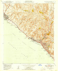
1949 Map of Laguna Beach
USGS Topo · Published 1949About this map
The San Joaquin Hills dominate the coastal topography of Orange County in the late 1940s, creating a series of dramatic drainages including Moro Canyon, Muddy Canyon, and Los Trancos Canyon that descend toward the Pacific. Along the shore, the community of Laguna Beach is anchored by landmarks such as the Art Gallery, Union High School, and Heisler Park. To the north, Corona del Mar and the southern edge of Newport Beach appear during a period of steady postwar growth along the Coast Highway. This map reveals the early development of the ridge-line community at Top of the World and the technical infrastructure of the era, including the Radio Station KTEO. The rugged coastline is defined by numerous points and coves like Emerald Bay and Crescent Bay, prior to the dense modern expansion of these seaside neighborhoods.
Find a feature on this map
56 named features on this map. Tap any name to fly to it.
Don’t see what you’re looking for? This feature index may not catch every label — zoom into the map to look around manually.
Map Details
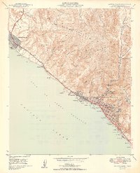
Editions of this 1949 Laguna Beach Map
2 editions found
Other maps of this area

1896 · Santa Ana
USGS Topo · 1:62,500

1901 · Southern California Sheet No. 1
USGS Topo · 1:250,000

1901 · Santa Ana
USGS Topo · 1:62,500

1902 · Capistrano
USGS Topo · 1:125,000

1902 · Corona
USGS Topo · 1:125,000

1904 · Southern California Sheet No. 2
USGS Topo · 1:250,000

1904 · Southern California Sheet No. 1
USGS Topo · 1:250,000

1906 · Capistrano
USGS Topo · 1:125,000

1932 · Newport Beach
USGS Topo · 1:31,680

1932 · Tustin
USGS Topo · 1:31,680