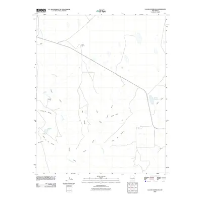
2010 Map of Laguna Huerfana
USGS Topo · Published 2010About this map
The Conchas River carves a deep path through this San Miguel County landscape, defining a network of drainage systems including Conchas Canyon and Box Canyon. The terrain is heavily marked by traditional landform names such as Valle Redondo and Cañon de las Cuevas, reflecting the deep-rooted cultural geography of northern New Mexico. Small settlements and points of interest like Harris, Schlothauer, and Naranjo are scattered across the quadrangle, connected by rural routes like County Road C 53 A. The presence of Greens Shipping Pens suggests the importance of livestock and ranching to the local economy during this era. Genealogists and historians will find value in the location of the Jimenez Cemetery and the natural watering points such as Conchas Spring and Crystal Lake, which likely served as anchors for early homesteads in this arid environment before reaching the eastern basin of Laguna Huerfana.
Find a feature on this map
23 named features on this map. Tap any name to fly to it.
Don’t see what you’re looking for? This feature index may not catch every label — zoom into the map to look around manually.
Map Details
Editions of this 2010 Laguna Huerfana Map
This is the sole edition of this map. No revisions or reprints were ever made.
Other maps of this area

1892 · Watrous
USGS Topo · 1:125,000

1892 · Corazon
USGS Topo · 1:125,000

1894 · Corazon
USGS Topo · 1:125,000

1894 · Watrous
USGS Topo · 1:125,000

1954 · Santa Fe
USGS Topo · 1:250,000

1958 · Santa Fe
USGS Topo · 1:250,000

1963 · Flagstone Mountain
USGS Topo · 1:24,000
1963 · Mesa Lauriano
USGS Topo · 1:24,000
1971 · Goetsch Lake
USGS Topo · 1:24,000

1971 · Laguna Huerfana
USGS Topo · 1:24,000