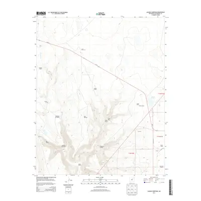
2013 Map of Laguna Huerfana
USGS Topo · Published 2013About this map
Jimenez Cem sits in the northwest quadrant of this San Miguel County landscape, marking the small settlement of Jimenez. This high-desert terrain is defined by the deep incision of the Conchas River and its complex network of canyons, including Cañon Hondo and the prominent Cañon de las Cuevas. The presence of Greens Shipping Pens along the NM-104 highway corridor suggests a ranching and livestock economy that utilizes the vast open spaces between these topographic breaks.
Find a feature on this map
27 named features on this map. Tap any name to fly to it.
Don’t see what you’re looking for? This feature index may not catch every label — zoom into the map to look around manually.
Map Details
Editions of this 2013 Laguna Huerfana Map
This is the sole edition of this map. No revisions or reprints were ever made.
Other maps of this area

1892 · Watrous
USGS Topo · 1:125,000

1892 · Corazon
USGS Topo · 1:125,000

1894 · Corazon
USGS Topo · 1:125,000

1894 · Watrous
USGS Topo · 1:125,000

1954 · Santa Fe
USGS Topo · 1:250,000

1958 · Santa Fe
USGS Topo · 1:250,000

1963 · Flagstone Mountain
USGS Topo · 1:24,000
1963 · Mesa Lauriano
USGS Topo · 1:24,000
1971 · Goetsch Lake
USGS Topo · 1:24,000

1971 · Laguna Huerfana
USGS Topo · 1:24,000