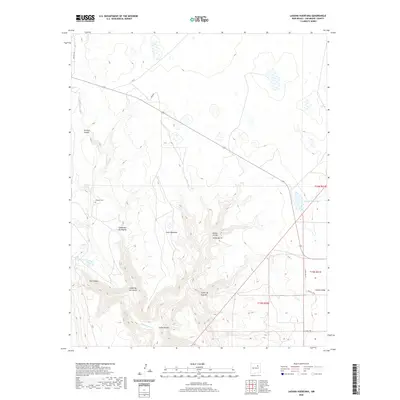
2020 Map of Laguna Huerfana
USGS Topo · Published 2020About this map
Conchas River and its intricate network of canyons define this landscape in San Miguel County. The terrain is deeply incised by water-carved features such as Conchas Canyon, Cañon Hondo, and Cañon de las Cuevas, which reveal a complex geography of high mesas and drainage basins. For local historians and genealogists, the Jimenez Cem stands as a significant cultural landmark in an area otherwise characterized by vast stretches of named terrain like Valle Redondo. Sources of water are clearly delineated, ranging from the natural Conchas Spring to Crystal Lake and the namesake Laguna Huerfana. This modern survey illustrates the persistent importance of cattle ranching and rural access in the high desert, with roads like Feed Rd and Co Rd C-50-D connecting these distant points of water and memory.
Find a feature on this map
25 named features on this map. Tap any name to fly to it.
Don’t see what you’re looking for? This feature index may not catch every label — zoom into the map to look around manually.
Map Details
Editions of this 2020 Laguna Huerfana Map
This is the sole edition of this map. No revisions or reprints were ever made.
Other maps of this area

1892 · Watrous
USGS Topo · 1:125,000

1892 · Corazon
USGS Topo · 1:125,000

1894 · Corazon
USGS Topo · 1:125,000

1894 · Watrous
USGS Topo · 1:125,000

1954 · Santa Fe
USGS Topo · 1:250,000

1958 · Santa Fe
USGS Topo · 1:250,000

1963 · Flagstone Mountain
USGS Topo · 1:24,000
1963 · Mesa Lauriano
USGS Topo · 1:24,000
1971 · Goetsch Lake
USGS Topo · 1:24,000

1971 · Laguna Huerfana
USGS Topo · 1:24,000