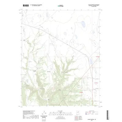
2023 Map of Laguna Huerfana
USGS Topo · Published 2023About this map
Conchas River drainage systems define this San Miguel County landscape, carving a network of deep canyons and seasonal waterways across the high terrain. The map documents a rugged topography of named arroyos and valleys, including Cañon de las Cuevas, Cañon Hondo, and the secluded Box Canyon north of Crystal Lake. This modern survey illustrates how traditional land use persists through cattle ranching and remote holdings, connected by a sparse network of ranch roads such as Feed Rd and Goetsch Ln.
Find a feature on this map
24 named features on this map. Tap any name to fly to it.
Don’t see what you’re looking for? This feature index may not catch every label — zoom into the map to look around manually.
Map Details
Editions of this 2023 Laguna Huerfana Map
This is the sole edition of this map. No revisions or reprints were ever made.
Other maps of this area

1892 · Watrous
USGS Topo · 1:125,000

1892 · Corazon
USGS Topo · 1:125,000

1894 · Corazon
USGS Topo · 1:125,000

1894 · Watrous
USGS Topo · 1:125,000

1954 · Santa Fe
USGS Topo · 1:250,000

1958 · Santa Fe
USGS Topo · 1:250,000

1963 · Flagstone Mountain
USGS Topo · 1:24,000
1963 · Mesa Lauriano
USGS Topo · 1:24,000
1971 · Goetsch Lake
USGS Topo · 1:24,000

1971 · Laguna Huerfana
USGS Topo · 1:24,000