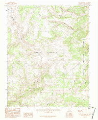
1983 Map of Lagunitas Creek
USGS Topo · Published 1983About this map
The Tierra Amarilla Grant Boundary cuts a significant diagonal across this high-altitude landscape, marking a legacy of land tenure in northern New Mexico. Situated within the Carson National Forest, the terrain is defined by a complex network of waterways, including the winding Rio Brazos and Rio San Antonio. The intersection of these drainage systems near areas like Brazos Meadows and Olguin Mesa illustrates the traditional upland grazing and water-rights patterns essential to the region's history. Distinctive geographical features such as the Bad Lands and the deep cuts of Tanques Canyon provide a detailed look at the erosional forces shaping the Rio Arriba highlands. Other smaller water bodies, including Gavilan Creek and Rio Nutritas, further map the intricate watershed that supported local land grants.
Find a feature on this map
18 named features on this map. Tap any name to fly to it.
Don’t see what you’re looking for? This feature index may not catch every label — zoom into the map to look around manually.
Map Details
Editions of this 1983 Lagunitas Creek Map
This is the sole edition of this map. No revisions or reprints were ever made.
Other maps of this area

1918 · Tusas
USGS Topo · 1:125,000

1954 · Aztec
USGS Topo · 1:250,000

1955 · Cebolla
USGS Topo · 1:62,500

1955 · Brazos Peak
USGS Topo · 1:62,500

1958 · Aztec
USGS Topo · 1:250,000

1962 · Aztec
USGS Topo · 1:250,000
1963 · Bighorn Peak
USGS Topo · 1:24,000

1963 · Broke Off Mountain
USGS Topo · 1:24,000

1963 · Burned Mountain
USGS Topo · 1:24,000

1965 · Aztec
USGS Topo · 1:250,000