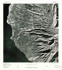
1978 Map of Lahaina
USGS Topo · Published 1981About this map
Lahaina serves as the primary coastal anchor in this late 1970s orthophotograph, showcasing the dense shoreline development before modern expansion. This unique aerial perspective reveals the intricate relationship between the coastal settlement and the vast agricultural fields that once dominated the West Maui slopes. Deep alluvial fans and erosion patterns are visible across the foothills, leading toward high terrain features such as Kauaula and the prominent peak of Lihau. To the south, the landscape rises toward Puu Mahanalua Nui, providing a clear view of the complex irrigation and land division patterns that defined the regional economy during this era. The transition from the developed waterfront at the Pacific Ocean to the high-elevation ridges offers a raw look at the island's mid-century land use.
Find a feature on this map
5 named features on this map. Tap any name to fly to it.
Don’t see what you’re looking for? This feature index may not catch every label — zoom into the map to look around manually.
Map Details
Editions of this 1978 Lahaina Map
This is the sole edition of this map. No revisions or reprints were ever made.
Other maps of this area

1954 · Maui
USGS Topo · 1:250,000

1954 · Maalaea
USGS Topo · 1:24,000

1955 · Olowalu
USGS Topo · 1:24,000

1955 · Wailuku
USGS Topo · 1:24,000

1955 · Kahakuloa
USGS Topo · 1:24,000

1956 · Lahaina
USGS Topo · 1:24,000

1956 · Honolua
USGS Topo · 1:24,000

1966 · Maui
USGS Topo · 1:250,000

1974 · Maui
USGS Topo · 1:250,000

1977 · Wailuku
USGS Topo · 1:24,000