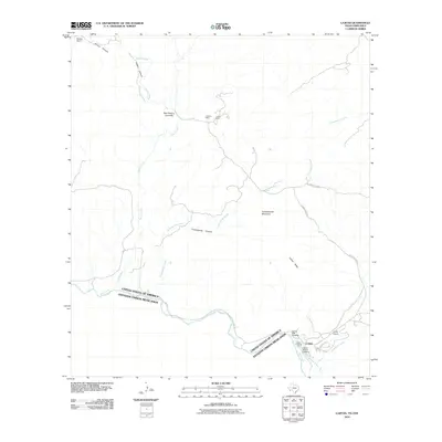
2010 Map of Lajitas
USGS Topo · Published 2010About this map
The Rio Grande forms the international boundary between the United States and Mexico in this arid borderland region. In the southeast corner, the settlement of Lajitas serves as a focal point for travel and transit, featuring the Lajitas Airport and several river access points including the Lajitas Boat Crossing and the Lajitas Vehicle Crossing. The landscape is defined by its deep drainage systems and prominent geological features, such as the curiously named Wax Factory Laccolith and the heights of Contrabando Mountain.
Find a feature on this map
25 named features on this map. Tap any name to fly to it.
Don’t see what you’re looking for? This feature index may not catch every label — zoom into the map to look around manually.
Map Details
Editions of this 2010 Lajitas Map
This is the sole edition of this map. No revisions or reprints were ever made.
Other maps of this area

1903 · Terlingua
USGS Topo · 1:125,000

1904 · Terlingua
USGS Topo · 1:125,000

1931 · Lajitas
USGS Topo · 1:62,500

1959 · Emory Peak
USGS Topo · 1:250,000

1965 · Emory Peak
USGS Topo · 1:250,000

1971 · Yellow Hill
USGS Topo · 1:24,000

1971 · Amarilla Mountain
USGS Topo · 1:24,000
1971 · The Solitario
USGS Topo · 1:24,000
1971 · Sauceda Ranch
USGS Topo · 1:24,000
1971 · Lajitas
USGS Topo · 1:24,000