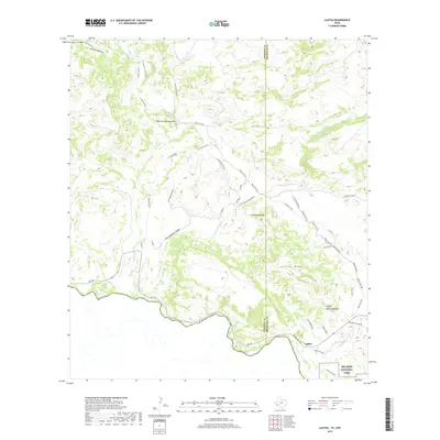
2019 Map of Lajitas
USGS Topo · Published 2019About this map
Lajitas sits on the northern bank of the Rio Grande, serving as a critical gateway where the high desert meets the river's edge. This 2019 survey documents a landscape defined by significant topographic shifts, from the prominent Lajitas Mesa and Comanche Mesa to the massive Wax Factory Laccolith. The map records a network of historical transit routes and resource extraction sites, including the N Lone Star Mine and a Rock Quarry. Local landmarks such as the Madrid House and the Lajitas Natural Bridge provide specific points of interest for historical research. Further south, the map details the entrance to Big Bend National Park near Mesa de Anguila, while to the north, drainage patterns like Fresno Canyon and Contrabando Canyon illustrate the complex hydrography feeding into the main river channel.
Find a feature on this map
37 named features on this map. Tap any name to fly to it.
Don’t see what you’re looking for? This feature index may not catch every label — zoom into the map to look around manually.
Map Details
Editions of this 2019 Lajitas Map
This is the sole edition of this map. No revisions or reprints were ever made.
Other maps of this area

1903 · Terlingua
USGS Topo · 1:125,000

1904 · Terlingua
USGS Topo · 1:125,000

1931 · Lajitas
USGS Topo · 1:62,500

1959 · Emory Peak
USGS Topo · 1:250,000

1965 · Emory Peak
USGS Topo · 1:250,000

1971 · Yellow Hill
USGS Topo · 1:24,000

1971 · Amarilla Mountain
USGS Topo · 1:24,000
1971 · The Solitario
USGS Topo · 1:24,000
1971 · Sauceda Ranch
USGS Topo · 1:24,000
1971 · Lajitas
USGS Topo · 1:24,000