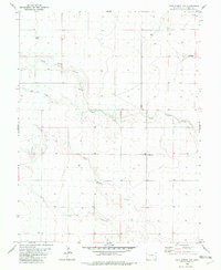
1982 Map of Lake Albert NW
USGS Topo · Published 1982About this map
White Woman Creek and South Ladder Creek define the drainage of this High Plains landscape in Cheyenne County, where the topography is shaped by wide, shallow draws and intermittent watercourses. The 1982 survey reflects a specialized agricultural and ranching environment, characterized by isolated infrastructure rather than concentrated settlements. Notable landmarks such as the Corral and various Well sites suggest the vital importance of water management and livestock movement in this portion of eastern Colorado. Human activity is further evidenced by a Gravel Pit near the creek bed and scattered Storage Bins used for local grain production. The presence of a Tank and a Drag illustrates the functional, working nature of the land during the early 1980s, providing researchers with a detailed look at rural utility and land use before modern technological shifts in farming.
Find a feature on this map
9 named features on this map. Tap any name to fly to it.
Don’t see what you’re looking for? This feature index may not catch every label — zoom into the map to look around manually.
Map Details
Editions of this 1982 Lake Albert NW Map
This is the sole edition of this map. No revisions or reprints were ever made.
Other maps of this area

1892 · Cheyenne Wells
USGS Topo · 1:125,000

1894 · Cheyenne Wells
USGS Topo · 1:125,000

1954 · Lamar
USGS Topo · 1:250,000

1958 · Lamar
USGS Topo · 1:250,000

1969 · Arapahoe SE
USGS Topo · 1:24,000

1969 · Cheyenne Wells 4 NE
USGS Topo · 1:24,000
1969 · Cheyenne Wells 4 SE
USGS Topo · 1:24,000

1981 · Cheyenne Wells
USGS Topo · 1:100,000
1982 · Cheyenne Wells
USGS Topo · 1:24,000
1982 · Lake Albert
USGS Topo · 1:24,000