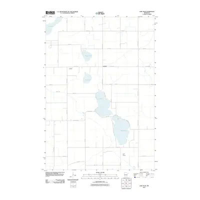
2010 Map of Lake Allie
USGS Topo · Published 2010About this map
Lake Allie and Preston Lake dominate the southern half of this landscape, forming a chain of glacial water bodies that influenced the local road network and settlement patterns. The small community of Lakeside is situated centrally along County Hwy-11, serving as a point of connection between these larger lakes and Phare Lake to the north. The area's history is anchored by early burial grounds, including the Preston Lake Cemetery near the southern shore and Evergreen Cemetery located further west near County Hwy-8.
Find a feature on this map
37 named features on this map. Tap any name to fly to it.
Don’t see what you’re looking for? This feature index may not catch every label — zoom into the map to look around manually.
Map Details
Editions of this 2010 Lake Allie Map
This is the sole edition of this map. No revisions or reprints were ever made.
Other maps of this area

1953 · New Ulm
USGS Topo · 1:250,000

1957 · New Ulm
USGS Topo · 1:250,000

1958 · New Ulm
USGS Topo · 1:250,000

1958 · Winthrop
USGS Topo · 1:62,500

1958 · Hutchinson
USGS Topo · 1:62,500

1964 · Buffalo Lake
USGS Topo · 1:24,000

1964 · Hector
USGS Topo · 1:24,000

1967 · New Ulm
USGS Topo · 1:250,000

1967 · Churchill
USGS Topo · 1:24,000
1967 · Cedar Mills
USGS Topo · 1:24,000