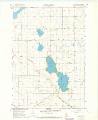
1967 Map of Lake Allie
USGS Topo · Published 1968About this map
The glacial prairie landscape of Renville County is defined here by a chain of significant water bodies, including Lake Allie and Preston Lake. This late 1960s survey illustrates a rural environment heavily modified for agriculture, evidenced by an extensive network of drainage infrastructure such as Judicial Ditch No 132 and County Ditch No 1. These channels navigate the flat terrain between Boon Lake and the meandering path of Buffalo Creek to the south.
Find a feature on this map
25 named features on this map. Tap any name to fly to it.
Don’t see what you’re looking for? This feature index may not catch every label — zoom into the map to look around manually.
Map Details
Editions of this 1967 Lake Allie Map
This is the sole edition of this map. No revisions or reprints were ever made.
Other maps of this area

1953 · New Ulm
USGS Topo · 1:250,000

1957 · New Ulm
USGS Topo · 1:250,000

1958 · New Ulm
USGS Topo · 1:250,000

1958 · Winthrop
USGS Topo · 1:62,500

1958 · Hutchinson
USGS Topo · 1:62,500

1964 · Buffalo Lake
USGS Topo · 1:24,000

1964 · Hector
USGS Topo · 1:24,000

1967 · New Ulm
USGS Topo · 1:250,000

1967 · Churchill
USGS Topo · 1:24,000
1967 · Cedar Mills
USGS Topo · 1:24,000