
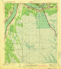
1935 Map of Lake Batola
USGS Topo · Published 1935About this map
Grand Lake and Lake Petit dominate this 1930s coastal landscape, where the labyrinthine waterways of Plaquemines Parish reveal a complex marsh environment before significant modern alteration. The map documents a network of bayous and lagoons, including Sun Lagoon and Shrimp Lagoon, which suggest the commercial fishing and trapping activities central to the local economy during this era. Landforms like Sun Pt and waterways such as Alligator Pass and The Greek provide specific geographic markers for navigating the wetlands.
Find a feature on this map
41 named features on this map. Tap any name to fly to it.
Don’t see what you’re looking for? This feature index may not catch every label — zoom into the map to look around manually.
Map Details
Editions of this 1935 Lake Batola Map
This is the sole edition of this map. No revisions or reprints were ever made.
Other maps of this area

1891 · Pointe a La Hache
USGS Topo · 1:62,500

1892 · St. Bernard
USGS Topo · 1:62,500

1892 · Pointe a La Hache
USGS Topo · 1:62,500

1893 · Shell Beach
USGS Topo · 1:62,500

1893 · Dime
USGS Topo · 1:62,500

1935 · Delacroix
USGS Topo · 1:31,680

1939 · Shell Beach
USGS Topo · 1:62,500

1939 · Pointe a La Hache
USGS Topo · 1:62,500
1940 · Belle Chasse
USGS Topo · 1:31,680

1941 · Black Bay
USGS Topo · 1:62,500