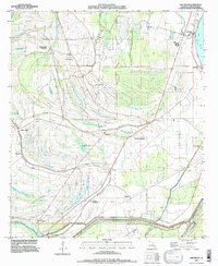
1994 Map of Lake Bruin
USGS Topo · Published 1997About this map
Thistle Ridge Plantation and Mound Plantation anchor a landscape defined by the complex hydrology of the Mississippi River floodplain in the mid-1990s. The terrain is marked by a intricate network of bayous and oxbow lakes, most notably Lake Bruin and the St Peter Lake system. The map reveals a transition between agricultural land and swampy lowlands, where Big Choctaw Bayou and Little Choctaw Bayou meander through the parish. Significant local infrastructure is evident near St Joseph, with the massive Levee protecting the low-lying settlements of Locust Ridge and Denhart. Genealogists may find value in the presence of scattered family-linked sites such as Gibson Plantation and small burial grounds including Cross Keys Cem and Oriental Cem, which reflect the long-standing community structure of Tensas Parish.
Find a feature on this map
44 named features on this map. Tap any name to fly to it.
Don’t see what you’re looking for? This feature index may not catch every label — zoom into the map to look around manually.
Map Details
Editions of this 1994 Lake Bruin Map
This is the sole edition of this map. No revisions or reprints were ever made.
Other maps of this area

1909 · Delta Bridge
USGS Topo · 1:24,000

1909 · Lake Bruen
USGS Topo · 1:24,000

1935 · Shackleford Lake
USGS Topo · 1:62,500

1939 · Lorman
USGS Topo · 1:62,500

1939 · Locust Ridge
USGS Topo · 1:62,500

1953 · Natchez
USGS Topo · 1:250,000

1955 · Jackson
USGS Topo · 1:250,000

1956 · Natchez
USGS Topo · 1:250,000

1958 · Shackleford Lake
USGS Topo · 1:62,500

1958 · St. Joseph
USGS Topo · 1:62,500