
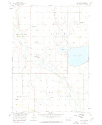
1956 Map of Lake Byron
USGS Topo · Published 1957About this map
Huron Colony sits at the center of this Beadle County landscape, where the meandering James River and Foster Creek converge. The area's water-dependent economy is evidenced by the presence of a Fish Hatchery on the western shore of Lake Byron and a series of Flowing Wells distributed throughout the townships of Pleasant View, Fairfield, and Iowa. These artesian wells were critical infrastructure for the agricultural developments mapped here in the mid-1950s.
Find a feature on this map
21 named features on this map. Tap any name to fly to it.
Don’t see what you’re looking for? This feature index may not catch every label — zoom into the map to look around manually.
Map Details
Editions of this 1956 Lake Byron Map
2 editions found
Other maps of this area

1895 · Byron
USGS Topo · 1:125,000

1898 · Huron
USGS Topo · 1:125,000

1953 · Huron
USGS Topo · 1:250,000

1954 · Huron
USGS Topo · 1:250,000

1956 · Lake Byron NW
USGS Topo · 1:24,000

1956 · Spink Colony
USGS Topo · 1:24,000

1956 · Lake Byron SE
USGS Topo · 1:24,000

1956 · Hitchcock SE
USGS Topo · 1:24,000

1958 · Huron NW
USGS Topo · 1:24,000
1958 · Huron NE
USGS Topo · 1:24,000