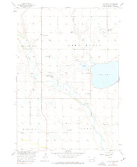
1956 Map of Lake Byron
USGS Topo · Published 1976About this map
The James River meanders through the heart of the Beadle County prairie, defining the landscape of Pleasant View and Iowa townships in the mid-1950s. Water dominates the eastern half of the map, centered on the expansive Lake Byron and its surrounding wetlands, including Connors Lake and Piper Lake. The area reflects a well-established agricultural community, evidenced by the presence of local civic markers like the Town Hall and educational sites such as Lake Byron Sch and School No 4.
Find a feature on this map
19 named features on this map. Tap any name to fly to it.
Don’t see what you’re looking for? This feature index may not catch every label — zoom into the map to look around manually.
Map Details
Editions of this 1956 Lake Byron Map
2 editions found
Other maps of this area

1895 · Byron
USGS Topo · 1:125,000

1898 · Huron
USGS Topo · 1:125,000

1953 · Huron
USGS Topo · 1:250,000

1954 · Huron
USGS Topo · 1:250,000

1956 · Lake Byron NW
USGS Topo · 1:24,000

1956 · Lake Byron
USGS Topo · 1:24,000

1956 · Spink Colony
USGS Topo · 1:24,000

1956 · Lake Byron SE
USGS Topo · 1:24,000

1956 · Hitchcock SE
USGS Topo · 1:24,000

1958 · Huron NW
USGS Topo · 1:24,000