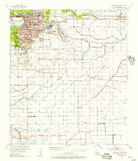
1955 Map of Lake Charles
USGS Topo · Published 1956About this map
The Lake Charles industrial and residential hub thrives along the Calcasieu River, serving as a critical junction for the Southern Pacific, Missouri Pacific, and Kansas City Southern railroads. This mid-century landscape is defined by its educational and military presence, from the campus of McNeese State College to the sprawling Lake Charles Air Force Base. The map reveals the expansion of postwar neighborhoods like University Place and Greinwich Village, while institutional history is noted through dozens of local schools including Boston High Sch and La Grange High Sch.
Find a feature on this map
78 named features on this map. Tap any name to fly to it.
Don’t see what you’re looking for? This feature index may not catch every label — zoom into the map to look around manually.
Map Details
Editions of this 1955 Lake Charles Map
3 editions found
Other maps of this area

1932 · Lake Charles NE
USGS Topo · 1:31,680

1932 · Moss Lake
USGS Topo · 1:31,680

1932 · Lake Charles NW
USGS Topo · 1:31,680

1932 · Lake Charles SW
USGS Topo · 1:31,680

1932 · Lake Charles SE
USGS Topo · 1:31,680

1934 · Lake Misere
USGS Topo · 1:24,000

1934 · Sweet Lake
USGS Topo · 1:24,000

1934 · Boudreaux Lake
USGS Topo · 1:24,000

1935 · Buhler
USGS Topo · 1:31,680

1935 · Moss Bluff
USGS Topo · 1:31,680