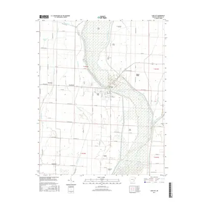
2017 Map of Lake City
USGS Topo · Published 2017About this map
Saint Francis River dominates the central geography of this 2017 survey, carving through a landscape defined by expansive bottomlands and islands. The settlement of Lake City sits on the western bank, serving as a focal point for the surrounding agricultural prairie. To the south and east, the map reveals the intricate water management system of the region, including Ditch Number 1 and Purcell Slough, which drain the low-lying reaches of Maumelle Prairie. Genealogists will find significant value in the distribution of local burial sites, from the central Lake City Cem to more remote locations like Upper Cane Island Cem and Lower Cane Island Cem. The map illustrates the persistence of small communities and crossroads such as Poplar Ridge, Southland, and Lunsford, documenting the modern footprint of these established Craighead County locales amid the productive fields of northeastern Arkansas.
Find a feature on this map
84 named features on this map. Tap any name to fly to it.
Don’t see what you’re looking for? This feature index may not catch every label — zoom into the map to look around manually.
Map Details
Editions of this 2017 Lake City Map
This is the sole edition of this map. No revisions or reprints were ever made.
Other maps of this area

1939 · Jonesboro
USGS Topo · 1:62,500

1940 · Dee
USGS Topo · 1:62,500

1941 · Leachville
USGS Topo · 1:62,500

1941 · Marked Tree
USGS Topo · 1:62,500

1953 · Memphis
USGS Topo · 1:250,000

1956 · Leachville
USGS Topo · 1:62,500

1956 · Marked Tree
USGS Topo · 1:62,500

1956 · Memphis
USGS Topo · 1:250,000

1958 · Dee
USGS Topo · 1:62,500

1958 · Jonesboro
USGS Topo · 1:62,500